Words as memory markers
Mention the words “road”, “fort” and “mountain” to a north American and he/she will probably think of a Western movie setting.
Mention the words “village” and “orchard” to a Russian and she/he will probably think of a Chekov play.
Mention all these words in sequence to long time Montreal residents and they will probably think of the “165 – Côte des Neiges” bus line.
You may think that the fort, mountain, village and orchard in question are strung along that road geographically, on different parts of the road, or you may think that they were on that road at different times in its history … and you would be right in both cases.
Why?
Because these words are still in use as names to identify places along this road as memory markers which, when applied to figures of the cityscape and its contextual landscape, become memory figures.
A memory figure is therefore both a historical and geographical element of the cityscape and landscape … it has a cognitive reality as much as an experiential one and, as such, affects us in understanding and appreciating our place in the city and its landscape … in space and time.
Of some memory figures along Côte-des-Neiges Road
The Road and the Côte.
In “Côte des Neiges Road”, the word road (in French “chemin”) refers to those pathways issued from the first fortified settlement of Ville Marie (first name of Montreal), and reaching across the width and breadth of the Island of Montreal to villages, and to sections of platted farmland, which the word côte refers to.
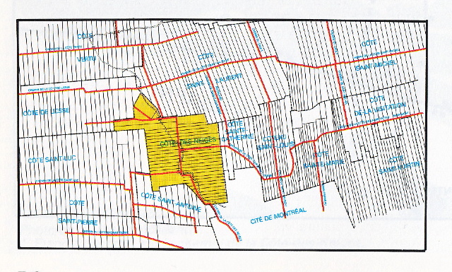
In the platting map shown above, referring to the 1850 situation, the Roads are in red and the “Côte des Neiges” section has been coloured in yellow, with the snaking dotted line referring to the brook used by the leather tanning craftsmen established in the old “Village of Côte des Neiges” , located at the first intersection with another road leading west.
The elongated farm lots are a typical Quebec settlement pattern taking root first along the St Lawrence river.
Road and côte are therefore two memory figures that speak of territorial identity.
The Mountain Fort … Condominium
When the original city planned its first expansion, it established defensive forts at the corners of the area considered.
One of them was located up the first rise toward the pass between the two summits of the mountain (Mount Royal today), on the south side of the Côte des Neiges Road.
Named the Mountain Fort, it is now gone, replaced by a seminary complex, but has given its name to a large upscale condominium between the seminary and Côte des Neiges Road proper, named Mountain Fort Condominiums.

Interesting to note how the residential complex has a fort-like massing, with a tunnel entrance leading to an interior open space, relieved only by its warm coloured brick and residentially scaled openings and details.
The name “Mountain Fort Condominium” was chosen mostly for its prestige historical location at mid slope up the Mountain and its associated feeling of security, rather than for any conscious expression of defensive purpose.
The Mountain Fort is therefore a tasteful, if physically obvious, memory figure!
The Gleneagles complex … at the mountain pass
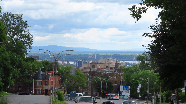
The way Côte des Neiges Road reaches the northern parts of the island is over a pass between the east and west summits of the Mountain (see feature image).
Around the pass we find country homes and a towering luxury apartment complex with arched fort-like entrances leading to an inside courtyard with private parking and ceremonial entrance to the building (see image below).

These buildings were built for the wealthy, with something like a private access to the Mount Royal Park designed by Olmsted (see stairs at end of right hand sidewalk), just a short walk across the old tram line that used to run up the Road.
Cars and buses and trucks whiz by now where the tram used to trundle … and the “eagles” are cooped up in their brick castle with an unrestricted view over the city to the river, and beyond to the U.S. border (see approximate view below, taken at street level).
The Gleneagles is a sweet-sour memory figure of the golden industrial era of Montreal, when the pass over the Mountain led to hunting grounds for the wealthy, before leading to farmland.
The Village Grocery
The Côte des Neiges Village Grocery was presented in my post titled “The Intersection”; I simply wish to add here that no other business in Côte des Neiges alludes to the Village of Côte des Neiges, established over three centuries ago by the leather tanners of the day.
It is more than a marketing trick—it is really a village grocery.
The crabby state of things on the outside hides a well stocked and run grocery with a first class meat counter, and with a personnel that has been in place for years: they know you when you come in … just like in a village, they take orders from older folks over the phone … just like in a village, and they will deliver if unable to carry the goods … just like in a village. (see image below)
The Marché du Village Côte des Neiges is a live memory figure … located a block away from the real old tanners Village of Côte des Neiges!

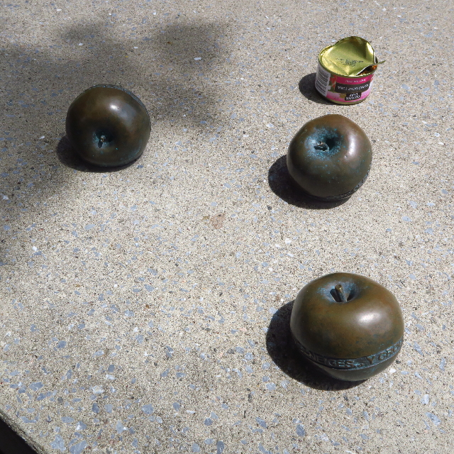
The symbolic mini-monument to the Apple Orchard
Given the fact that the Côte des Neiges farmland was known for its apple orchards, when the time came to line Côte des Neiges Road with mementos of what it used to cross on its way north, a competition was held, with the resulting installation of sets of concrete tables and seats at various points along the original edges of the road, with bronze cast apples placed on them, inscribed with the names of some of the original apple orchard farmers.
Note: the empty salmon can in the image was there when I took the photograph … a lady was finishing her lunch and I asked her to leave the can there, as evidence of the use of the tables, in the benign presence of the symbolic Apple Orchard “mini-monument” (see image below).
These bronze apples are a very discrete memory figure, yet one that cannot be missed, and one that has yet to be tempered with … “Ars longa” as they say!
Discussion
The “Road” and “Côte” as cityscape “Front”
From the layout of the Côte des Neiges Road northward into the island over the mountain pass, through the various stages of its settlement … that “chemin” or road of first exploration and settlement has concentrated over the years the energy of expansion of the city into the country side.
One can imagine the trail that started it all, then the widening and grading and paving and furnishing of it, as the road arrived to its current state, historically benefiting the development of farmland first, then the residential and institutional developments serving the growing population of the city: duplexes and multi family apartment blocs, university, private schools, hospitals, religious oratory, and commercial centers.
In his “Close up – Reading the American city,” Grady Clay calls the line where a cityscape meets the landscape, gradually pushing it as it grows, an “urban front,” as in a moving battle “front line.”
When one thinks of the investment made by the city from its pioneering days to today in the building of the “Côte des Neiges Road” , and the “Côte des Neiges” proper, these can be considered and appreciated as being the result of such an urban front moving process, that deserved to be recognized in the “memory figures” discussed in this post.
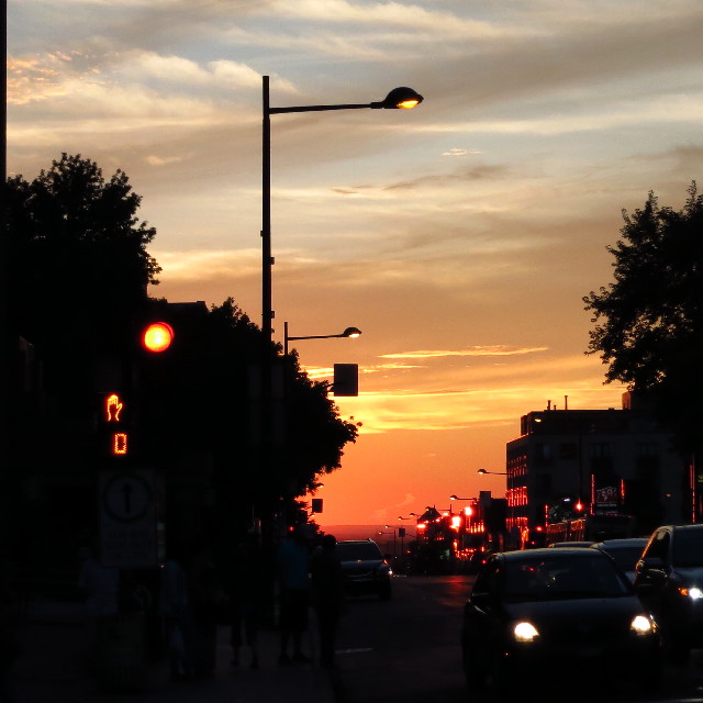
Enjoy the view down Côte des Neiges Road, looking northwest on a summer sunset … while I go back to more summering … and reporting!
Credits:
Survey map of Montreal farmland platting: credit “Les Quartiers de Montreal” by M. Gagnon and R. Gratton, Guérin editor, 1991, Montreal. p.200.
Sketch and photos: credit Maurice Amiel